100 million years ago an ancient river carved its way through the Southern High Plains, slowly exposing the previous 150 years of geologic stories in vast, panoramic canyon vistas. Today the Palo Duro Canyon near Amarillo, Texas is the second largest canyon in the country at 120 miles long and 600-800 feet deep.
Home to abundant wildlife, wild grasses, hardwoods and evergreen junipers, the canyon also holds the memories and artifacts of 12,000 years of human habitats. A little over 200 years ago the native Southern Plains tribes were decimated and relocated to reservations in Oklahoma. Wild buffalo were slaughtered to make way for a few white barons and their herds of longhorn cattle.
In 1933, private owners deeded 27,173 acres to national parklands. Over the next year companies of young men and military veterans working for the Civilian Conservation Corps created roads, a visitor center, cabins, shelters, bridges, and trails throughout the park. Today visitors to this Texas State Park can camp in tents, RV’s, and cabins. Visitors can explore canyon rim to floor on miles of hiking, horse and dirt bike trails.
This is a great state park in winter, spring, and fall. (Summer heat and humidity can be a bit much.)
The Hackberry Campground offers the perk of electricity, water and showers without the annoyance of massive RV’s stacked on top of each other. This camp has 30 amp hook ups and attracts folks with smaller RV’s and tent campers. There is vegetation for shade and privacy. Abundant wildlife gathers at the creek running along the cliffs at the back of the canyon.
Electric and water hookups are $22/night. Camp sites on outer loops back up to the creek and offer more privacy. Reservations can be made online, as walk up, or by phone (512) 389-8900.
The Texas State Park Annual Pass is accepted in Palo Duro. The $70 pass provides unlimited free entry to 90 state parks and discounts at campsites, park stores, gift shops, and recreational equipment rental.
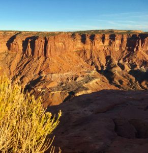
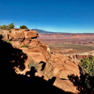
The heart and soul of the Colorado Plateau in southern Utah is expressed through canyons, arches, spires, and mesas carved by the Green and Colorado Rivers.
It’s almost impossible to wrap my mind around so much stunning beauty but it is as natural as breathing to allow all of that to become all of me. In my prayers and practices it also flows to each of you.
If you’d like to experience it yourself two national parks help millions access some of the area annually – Arches and Canyonlands. Fortunately most stay on the paved, scenic routes highlighting the parks.
Inside both parks there is no food, gas, or other amenities. Each has one national parks campground.
Most of the roads in this region are unpaved, camps are primitive, and rivers are free-flowing. Native plants and animals still live in much of this remote, rugged, and wild countryside. Lots of folks call it “The American Wild West” but it’s been around much longer than we have and God willing will continue long after we’re gone.
Please do your part to protect this ancient, wild land. Follow “Leave No Trace” rules especially in designated and dispersed camping, hiking, biking, and OHV adventures.
Photo courtesy Dr. Eoin Brodie at Lawrence Berkeley National Lab and Dr. Ferran Garcia Pichel at Arizona State University.
Here’s the deal. The biological soil crust is extremely fragile in the desert. The cyanobacteria and other materials in the soil are some of the oldest life forms, trapping and storing water, nutrients, and organic matter not otherwise available. It’s suited for harsh, arid conditions but vulnerable to compression.
A thin, fragile veneer of biological soil crushed by your footprints alone (compression) may require five to seven years to recover. Cyanobacterial growth can take 50 years and lichens/mosses even longer.
Each national park has one developed campground with vault toilets, tables, and fire rings. Maximum length for RVs is 28 feet. There are no hook ups or dump stations in either park. Most are first come, first served except group campsites and a few individual sites. To reserve online go to http://www.recreation.gov or call 877-444-6777 (toll free) and +1 518-885-3639 (international).
Backcountry or Primitive Camps in the national parks require permits. These can be reserved four months in advance. Day use for 4×4 vehicles, motorcycles, and bikes can be reserved up to 24 hours in advance. Permits can be obtained online at http://www.go.nps.gov/canybackcountry
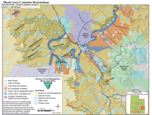
The BLM maintains 26 designated campgrounds with vault toilets, tables and fire rings. Drinking water is available at Lions Park (Hwy 191 and SR 128). The Windwhistle and Hatch Point campgrounds have drinking water on site from mid-April to end of September.
The Moab BLM Field Office manages over two million visitors annually on 1.8 million acres in the heart of the Colorado Plateau.
Reservations are not accepted except group camps. All are first come first served. All BLM developed campgrounds have vault toilets, picnic tables, and metal fire grills. Fees are $10-$20/night.
Weather can make unpaved roads impassable. Check with rangers for latest conditions.
The Visitor Centers at Arches and Canyonlands have detailed maps for 4×4 routes, hiking and camping. Topo maps are also available.
Developed Campsites
SR 313 Camps Between Arches and Canyonlands Island In the Sky National Parks
Lone Mesa Group Camp
(5 spaces)
Gravel road and camp
Cowboy Camp at junction of Scenic Byway and Island in Sky
(7 spaces)
Dirt road and camp
Horsethief off Mineral Point Road by Deadhorse Mesa.
(56 spaces)
Dirt road and sandy, flat area for camp. This is where larger RV’s park.
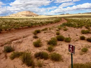
The BLM offers over 30 single or small, primitive camp sites with no services. These are first come-first served and free. Sites are marked with a brown post and a tent symbol.
Dispersed campsite off SR 313
This is serious “Leave No Trace” camping. You must use portable toilets. All trash must be packed out – including human waste. No wood cutting, creating new camping areas or fire rings. Do not drive, hike, ride off road. Please.
There are 25 sites in the Mill Canyon-Cotter Road/Dubinky Road Area.
Accessible by 4×4 Taylor Canyon, White Rim, Potash, and Shafer Roads
4 primitive camps along Green River
Labyrinth – Where Taylor Canyon Road meets White Rim Road on the Green River in Upheaval Canyon
Hardscrabble – South of Hardscrabble Bottom
Potato Bottom – along the 14.8 mile Potato Bottom straight stretch of White Rim Road
Candlestick – Southern part of Holesman Spring Basin. South of Wilhite Trail on White Rim Road
4 primitive camps on southern loop of White Rim Road
Murphy Hogback – near Murphy Point trails
White Crack – in the Lower Basins at end of 1.4 mile road
Gooseberry – where trail meets road near Gooseberry Canyon
Airport – By Airport Tower in Lathrop Canyon
1 primitive camp near Visitors Center
Shafer Canyon Overlook by Visitors Center
Shafer Near Visitors Center NE of where Potash Road meets Shafer Trail Road, Shafer Canyon. This gives access to the spectacular Goose Neck area of the Colorado River.
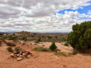
Can you find me and Rocky in this photo?
No matter where you may set up camp you’ll discover tons of ways to wear yourself slick having adventure fun. Remember to take some time to sit and stare for awhile. You’ll be glad you did.
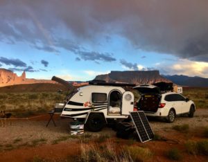
Following trails that beckon is life at it’s best. Free wandering with no schedule or goals has served me well since childhood exploring creeks and prairies. I’ve been trained to watch and wait for the guidance but I’ll admit there’s is a new learning curve with the addition of the off-road teardrop camper. It’s keeping my guardian angels – and me – wide awake.
This day was for exploring the BLM off-roads outside Moab, Utah. No map, no cell service and no worries. It’s a Subaru with ample off-road GPS coverage right? A dropped pin marked the starting point and I was free to breathe in jaw-dropping vistas. It was an easy trail with occasional rough rocks or sinking sand spots.
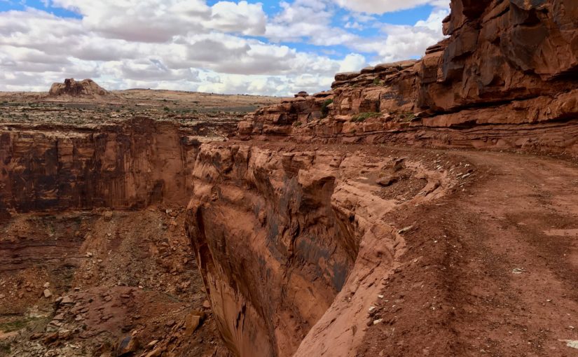
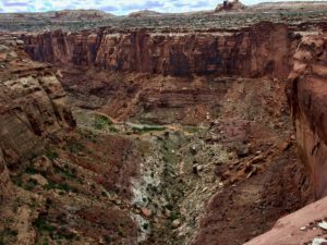
The road transformed to true 4×4 when I turned a corner and hit the brakes. A gate in the middle of nowhere? Prying it open was easy since it wasn’t locked so I squeezed my rig through. That’s when the reality of The Canyon slapped me.
Narrow, ridiculously steep grade, no safety rails and the most amazing, adrenaline-inducing experience calling my name! The Subaru and teardrop had torn up off roads for days and I was primed for the grand prize dive down The Canyon.
I glanced at Rocky’s wide, trusting smile and immediately saw my four spectacular adult kids expecting me home for the holidays. A raven flew overhead mimicking Daddy’s familiar refrain “pull your head out of your ass Cindy!”
Perhaps a bit of recon was in order. Rapid, shallow breathing and heart-pounding adrenaline with knees bent, eyes straight ahead helped resist the abyss tractor beam pulling me over the edge on the switchback curves. Barely. There was just enough width for the car and RV. No margin for error, changing my mind or turning around. There might be a clearance and mud issue. But I was a hound dog on a scent. Ride The Canyon or bust!
Admittedly I’ve got a few marks from life “or bust” experiences and a bit of a hang up about being the only surviving parent.
Time to pull out the big guns and use a technique honed over eight years in the halls of MD Anderson Cancer Center. Call in my angels when stakes are life OR death high. Employ the hallowed Coin Toss. Best two out of three wins. Heads means I go for it, tails I turn around and find a camp for the night.
First toss – heads. Second – tails. Standing inches from the cliffhanger I breathed in the delicious knowing that the outcome of that third toss would be my best option. No doubts. Pure faith. In that breath all the hooks and attachments of the adventure, adrenaline, and drama vanished. No need to do anything. Just lean in. Be still and know. The final toss and knowing occurred simultaneously. Tails. I’m out.
My best guess is I was in the Sheep Canyon area. GPS noted Mineral and Dead Horse Point Roads. I found an OHV trail map sign post indicating I was somewhere in the Dubinky area. Maybe The Canyon was a piece of Hell Roaring or Chicken Corners Trails. The coin toss occurred at the point requiring gate entry, is pinched between rocks on the right and the abyss on the left and drops over 1,000 feet via narrow, rocky, muddy switchbacks. Chicken Corners is where Moab area guides allow “chicken” passengers to walk, rather than ride. And Hell Roaring Canyon descriptions involve the word “pucker.”
I probably have too much faith in Beverly (my Subaru Outback) but I think she’d make The Canyon. Pulling my Outback teardrop camper affectionally dubbed Hillbilly? Sheer lunacy.
I can count on two things in life. My free spirit is comfortable with blind, ignorant leaps and it can heal more than it hurts if my heart stays open. May this inner knowing, my guardians, and the sacred Coin Toss always have my back!

 Home to abundant wildlife, wild grasses, hardwoods and evergreen junipers, the canyon also holds the memories and artifacts of 12,000 years of human habitats. A little over 200 years ago the native Southern Plains tribes were decimated and relocated to reservations in Oklahoma. Wild buffalo were slaughtered to make way for a few white barons and their herds of longhorn cattle.
 This is a great state park in winter, spring, and fall. (Summer heat and humidity can be a bit much.)
 vegetation for shade and privacy. Abundant wildlife gathers at the creek running along the cliffs at the back of the canyon.
 The heart and soul of the Colorado Plateau in southern Utah is expressed through canyons, arches, spires, and mesas carved by the Green and Colorado Rivers.
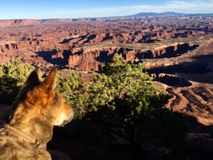 It’s almost impossible to wrap my mind around so much stunning beauty but it is as natural as breathing to allow all of that to become all of me. In my prayers and practices it also flows to each of you.
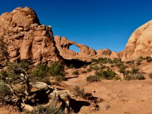 Inside both parks there is no food, gas, or other amenities. Each has one national parks campground.
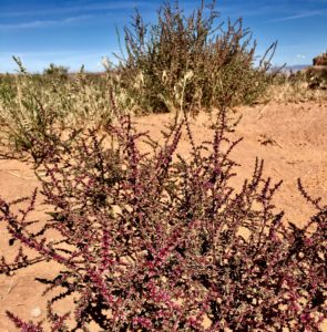 and animals still live in much of this remote, rugged, and wild countryside. Lots of folks call it “The American Wild West” but it’s been around much longer than we have and God willing will continue long after we’re gone.
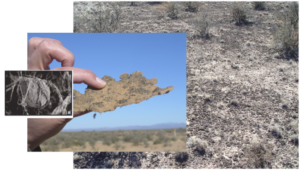
 A thin, fragile veneer of biological soil crushed by your footprints alone (compression) may require five to seven years to recover. Cyanobacterial growth can take 50 years and lichens/mosses even longer.
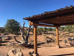
 The Moab BLM Field Office manages over two million visitors annually on 1.8 million acres in the heart of the Colorado Plateau.
 Weather can make unpaved roads impassable. Check with rangers for latest conditions.
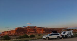 Lone Mesa Group Camp
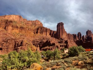

 Hardscrabble – South of Hardscrabble Bottom
 Murphy Hogback – near Murphy Point trails
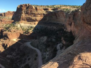
 Narrow, ridiculously steep grade, no safety rails and the most amazing, adrenaline-inducing experience calling my name! The Subaru and teardrop had torn up off roads for days and I was primed for the grand prize dive down The Canyon.
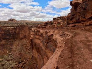 Perhaps a bit of recon was in order. Rapid, shallow breathing and heart-pounding adrenaline with knees bent, eyes straight ahead helped resist the abyss tractor beam pulling me over the edge on the switchback curves. Barely. There was just enough width for the car and RV. No margin for error, changing my mind or turning around. There might be a clearance and mud issue. But I was a hound dog on a scent. Ride The Canyon or bust!
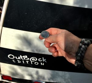 Time to pull out the big guns and use a technique honed over eight years in the halls of MD Anderson Cancer Center. Call in my angels when stakes are life OR death high. Employ the hallowed Coin Toss. Best two out of three wins. Heads means I go for it, tails I turn around and find a camp for the night.
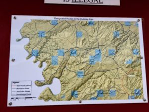 My best guess is I was in the Sheep Canyon area. GPS noted Mineral and Dead Horse Point Roads. I found an OHV trail map sign post indicating I was somewhere in the Dubinky area. Maybe The Canyon was a piece of Hell Roaring or Chicken Corners Trails. The coin toss occurred at the point requiring gate entry, is pinched between rocks on the right and the abyss on the left and drops over 1,000 feet via narrow, rocky, muddy switchbacks. Chicken Corners is where Moab area guides allow “chicken” passengers to walk, rather than ride. And Hell Roaring Canyon descriptions involve the word “pucker.”
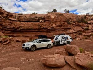 I probably have too much faith in Beverly (my Subaru Outback) but I think she’d make The Canyon. Pulling my Outback teardrop camper affectionally dubbed Hillbilly? Sheer lunacy.